In the first post of 2016, I decided to bring a cool use of OLE Automation procedures to query information about an address using the ZIP code or return the ZIP code (and other information) from an address. I had already demonstrated this before in the posts How to query information from a ZIP code in SQL Server (where I used the viacep.com.br service) and Consuming the Google Maps API using OLE Automation (where only the city was passed as a parameter), but I decided to create a slightly more complete procedure this time and again using the Google Maps API.
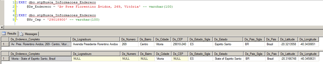
The main idea is that with the same Stored Procedure, it is possible to work in both ways (informing street or zip code) and return the data in the same way. I used some transformations on the input parameters to ensure that the search was as correct as possible and I had a little work to process the return in XML, so it was cool to practice a little (later I need to make a post about processing XML in SQL Server... lol)
Let's get to the point.
CREATE PROCEDURE [dbo].[stpBusca_Informacoes_Endereco] (
    @Ds_Endereco VARCHAR(500) = NULL,
    @Nr_Cep VARCHAR(9) = NULL
)
AS BEGIN


    SET NOCOUNT ON


    SET @Ds_Endereco = NULLIF(@Ds_Endereco, '')
    SET @Nr_Cep = NULLIF(@Nr_Cep, '')


    IF (@Ds_Endereco IS NULL AND @Nr_Cep IS NULL)
        RETURN


    ------------------------------------------------------------------------
    -- RECUPERAÇÃO DAS INFORMAÇÕES
    ------------------------------------------------------------------------

    DECLARE
        @obj INT,
        @Url VARCHAR(8000),
        @resposta VARCHAR(8000),
        @xml XML,
        @endereco_busca VARCHAR(4000)


    IF (@Nr_Cep IS NOT NULL AND @Ds_Endereco IS NULL)
        SET @endereco_busca = LEFT(@Nr_Cep, 5) + '-' + RIGHT(@Nr_Cep, 3) + ', Brasil'
    ELSE
        SET @endereco_busca = @Ds_Endereco


    SET @Url = 'http://maps.googleapis.com/maps/api/geocode/xml?address=' + @endereco_busca + '&sensor=false'

    EXEC sys.sp_OACreate @progid = 'MSXML2.ServerXMLHTTP', @objecttoken = @obj OUT, @context = 1
    EXEC sys.sp_OAMethod @obj, 'open', NULL, 'GET', @Url, false
    EXEC sys.sp_OAMethod @obj, 'send'
    EXEC sys.sp_OAGetProperty @obj, 'responseText', @resposta OUT
    EXEC sys.sp_OADestroy @obj


    SET @xml = @resposta COLLATE SQL_Latin1_General_CP1251_CS_AS


    ------------------------------------------------------------------------
    -- TRATAMENTO DO XML
    ------------------------------------------------------------------------

    IF (OBJECT_ID('tempdb..#XML') IS NOT NULL) DROP TABLE #XML
    CREATE TABLE #XML (
        Dados XML
    )

    INSERT INTO #XML
    SELECT Tabela.coluna.query('.') AS Resultado
    FROM @xml.nodes('/GeocodeResponse/result/address_component') Tabela(coluna)


    IF (OBJECT_ID('tempdb..#Endereco') IS NOT NULL) DROP TABLE #Endereco
    CREATE TABLE #Endereco (
        Ds_Tipo VARCHAR(100),
        Ds_Subtipo VARCHAR(100),
        Ds_ShortName VARCHAR(200),
        Ds_ShortName2 VARCHAR(200),
        Ds_LongName VARCHAR(500)
    )

    INSERT INTO #Endereco
    SELECT
        Dados.query('address_component/type[1]').value('.', 'varchar(100)') AS Ds_Tipo,
        Dados.query('address_component/type[2]').value('.', 'varchar(100)') AS Ds_Subtipo,
        Dados.query('address_component/type[3]').value('.', 'varchar(100)') AS Ds_Subtipo2,
        Dados.query('address_component/short_name').value('.', 'varchar(200)') AS Ds_ShortName,
        Dados.query('address_component/long_name').value('.', 'varchar(500)') AS Ds_LongName
    FROM
        #XML


    INSERT INTO #Endereco
    SELECT
        'formatted_address',
        'formatted_address',
        '',
        '',
        @xml.value('(/GeocodeResponse/result/formatted_address)[1]', 'varchar(500)')


    INSERT INTO #Endereco
    SELECT
        'latlon',
        'latitude_longitude',
        '',
        @xml.value('(/GeocodeResponse/result/geometry/location/lat)[1]', 'varchar(100)'),
        @xml.value('(/GeocodeResponse/result/geometry/location/lng)[1]', 'varchar(100)')


    ------------------------------------------------------------------------
    -- RESULTADO FINAL
    ------------------------------------------------------------------------

    SELECT
        MAX(CASE WHEN Ds_Tipo = 'formatted_address' THEN Ds_LongName END) AS Ds_Endereco_Completo,
        MAX(CASE WHEN Ds_Tipo = 'route' THEN Ds_LongName END) AS Ds_Logradouro,
        MAX(CASE WHEN Ds_Tipo = 'street_number' THEN Ds_LongName END) AS Ds_Numero,
        MAX(CASE WHEN Ds_Tipo = 'sublocality_level_1' OR Ds_Subtipo = 'sublocality_level_1' OR Ds_Subtipo2 = 'sublocality_level_1' THEN Ds_LongName END) AS Ds_Bairro,
        MAX(CASE WHEN Ds_Tipo = 'administrative_area_level_2' THEN Ds_LongName END) AS Ds_Cidade,
        MAX(CASE WHEN Ds_Tipo = 'postal_code' THEN Ds_LongName END) AS Ds_CEP,
        MAX(CASE WHEN Ds_Tipo = 'administrative_area_level_1' THEN Ds_ShortName END) AS Ds_Estado_Sigla,
        MAX(CASE WHEN Ds_Tipo = 'administrative_area_level_1' THEN Ds_LongName END) AS Ds_Estado,
        MAX(CASE WHEN Ds_Tipo = 'country' THEN Ds_ShortName END) AS Ds_Pais_Sigla,
        MAX(CASE WHEN Ds_Tipo = 'country' THEN Ds_LongName END) AS Ds_Pais,
        MAX(CASE WHEN Ds_Tipo = 'latlon' THEN Ds_ShortName END) AS Ds_Latitude,
        MAX(CASE WHEN Ds_Tipo = 'latlon' THEN Ds_LongName END) AS Ds_Longitude
    FROM
        #Endereco


END
sql, sql server, ole automation, google maps api, zip code query, zip code search, how to query a zip code, retrieve return zip code address

Comments (0)
Loading comments...